At Large  August 12, 2022  Danielle Vander Horst

Vulci 3000 Investigates Ancient Roman Water Systems

Credit: Danielle Vander Horst.

Fabio Fiocchi descends on a roped safety system into a cistern cavern at Vulci. To do such requires training and safety certifications.

We all need water. No matter where, no matter when, human life cannot survive without it. This has been made acutely and painfully apparent across large swaths of the globe this summer as human-driven climate change has fueled water shortages with detrimental effects to both the environment and human life.

It is perhaps not surprising then that when faced with the challenges of water management and distribution in our own time, there are those who look to the past with questions of how such problems were encountered and handled by our predecessors.

Such queries are taking precedence at Vulci 3000 this year, and they also drive the thoughts behind the work of others such as Dr. Dylan Rogers (Florida State University), author of the 2018 publication, Water Culture in Roman Society.

Courtesy of the Vulci 3000 Project.

An overhead view of the Vulci 3000 Project. Green circles are cisterns, purple ovals are pipelines/water channels, and red circles are wells. More of these features also exist to the West but are currently not being excavated.

The Vulci archeological park spans roughly 900 hectares, but just within the approximately 350 m2 (0.035 hectares) portion of the site that Duke University currently excavates, archeologists have found at least three wells, two cisterns, and two pipelines or water channels. The layering of all these features within even this small sliver of the city showcases just how intrinsic it was to have water woven into the urban fabric of the ancient city and to make use of existing structures wherever possible.

It is exactly this “impressive” layered continuity between the multiple phases of the site that strike researchers such as Dr. Rogers the most.

The Roman Empire was a grand and diverse place, stretching from the Atlantic to the Red Sea. It was thus crucial to have adaptable and strategic plans for dealing with water in myriad environs.

Credit: Dylan Rogers.

Dr. Dylan Rogers stands before the Roman Nymphaeum at Jerash, Jordan.

One of Dr. Rogers’ main interests is the adaptability displayed by Roman infrastructural water schemes. “The Romans were keenly aware of water shortage issues,” Dr. Rogers says. “This is why it’s important to look at water across the Roman Empire and not just one or two cities. For example, Britain has a very different climate from Jordan, so how the Romans controlled water in those two places was drastically different.”

In Roman Jordan, for instance, recent studies have shown that monumental fountains, similar in size to those found in other more water-saturated provinces, would have actually had only a “small trickle” of water running through them. Dr. Rogers points to such examples as clear evidence that the Romans “knew that they had to conserve their water and that they couldn’t waste it.” Such a tactic of conservation is necessary in Italy today with many of Rome’s public fountains and waterspouts turned off due to the summer intensity of climate change.

But the use of Roman water is far from limited to structures of public display. From their battlefields to their bathhouses, the Roman Empire was built on a network of water that would come to define many aspects of the Roman way of life in every part of the empire.

Not only did water support aspects of daily and religious life, but the Romans even fostered the growth of touristic and economic networks of water (control of the Mediterranean Sea contributing no small part to the latter). In the interest of building an empire, continuity for local, conquered populations was critical and thus these networks were especially successful in places with high levels of pre-Roman water usage, particularly locations centering around natural springs or thermal baths.

The Tabula Peutingeriana, a thirteenth-century copy of a possibly fourth-century Roman map, displays the late Empire. Dr. Rogers notes that “if you follow the roads, what the Romans really mark out are the spas, the thermal places.”

Detail of the Tabulae Peutingeriana, a thirteenth-century copy of a possible fourth to fifth-century Roman original map of the Empire. The map depicts notable landmarks and places of interest including many thermal spas and water features.
WikiMedia.

Detail of the Tabulae Peutingeriana, a thirteenth-century copy of a possible fourth to fifth-century Roman original map of the Empire. The map depicts notable landmarks and places of interest including many thermal spas and water features.

Four silver beakers found at Vicarello, Italy. Each cup has inscribed upon it a travel itinerary that one could follow in the Roman period with many stops including thermal spas and other important water features and sites.
Wikimedia.

Four silver beakers found at Vicarello, Italy.

Materials recovered by archeologists corroborate the existence of these networks. Small cups found at Vicarello, Italy denote a travel itinerary all the way from Rome to Cadiz, Spain with many of the stops being thermal spas, lakes, or locations with important water features along the way.

But how do archeologists recover some of what we know about ancient water? Much of what we know is visible from the surface—fountains and arched-aqueducts—however so much more than what we can see is integral to the real story.

The vast majority of Roman aqueducts were actually underground pipelines and many ancient peoples obtained their daily water from wells and cisterns beneath the surface; much like those discovered at Vulci. Things like pipelines and buried aqueducts lines can usually be excavated by any archeologist, but wells and cisterns present their own unique challenges and dangers. The proper excavation of such features often requires not only a specialized knowledge of their structural properties but additional training in the safety of working in tight, confined, or underground environments.

Fabio Fiocchi is one of the few archeologists who has both the structural specialization in wells and cisterns and the speleological safety certification to properly excavate them. For the last two seasons, he has worked at Vulci, excavating anywhere between seven and ten meters below the surface—though that is certainly not the deepest he has worked with some wells reaching depths of twenty-five meters.

Credit: Danielle Vander Horst.

Fabio Fiocchi within a cistern at Vulci. Very little sunlight reaches the bottom of the cistern and so Fiocchi must work predominantly by headlamp light.

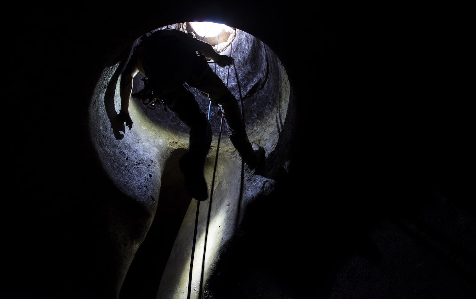
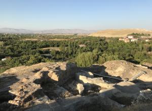
“It is dangerous work,” says Fiocchi. “There aren’t so many incidents but when things do go wrong they tend to be quite bad.” Each day at Vulci, Fiocchi must recycle the air in the cistern he excavates, taking out the stale air and then replacing it with fresh air from outside with a ventilator before scaling down a roped safety system. In the cistern, he works by helmet-light and whatever sunlight can reach him from above, the intermittent beeping of an air quality device letting him know the air is still safe to breathe.

At Vulci, Fiocchi works with a local safety engineer to ensure that the risks are as minimal as possible, however, there are always risks of dangerous air quality, failed safety systems, and human error. The mechanics of excavating itself in these types of structures can also prove challenging in its own right. While the cistern at Vulci is relatively simple with a straight channel leading into a bell-shaped space, Fiocchi has encountered other much more challenging wells and cisterns with slanted or even curved entrances and exits. Forms such as these increase the risk of falling materials and damage to the structures themselves when attempting to take earth and materials out.

Despite these challenges and dangers, however, Fiocchi says the work is worth it. “There aren’t so many people who are able to do this kind of work,” he notes, “and so very often these structures are ignored or excavated very poorly. But if you dig them properly you can obtain an incredible amount of data from these structures.”

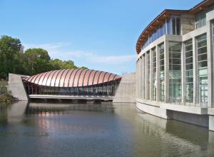
At Vulci in particular, 3D models, coupled with soil sample analyses and the study of the materials found within, will provide archeologists with micro-levels of information about the cistern when it was in use, when it was abandoned, and later when it was filled and sealed.

New information about all of these important milestones in the life of just one cistern can tell us countless things about who used it, for what, when, and how it helped to sustain and support the life of people thousands of years ago with the water it once held.

About the Author

Danielle Vander Horst

Dani is a freelance artist, writer, and archaeologist. Her research specialty focuses on religion in the Roman Northwest, but she has formal training more broadly in Roman art, architecture, materiality, and history. Her other interests lie in archaeological theory and public education/reception of the ancient world. She holds multiple degrees in Classical Archaeology from the University of Rochester, Cornell University, and Duke University.

Subscribe to our free e-letter!

Webform

Latest News

Artists Across Russia Raided by Security Service

Last week, the Russian Federal Security Service (FSB) raided…

Tom Burckhardt Show Explores Figurative Abstraction
Tom Burckhardt's exhibition Ulterior Motif, at George Adams Gallery, explores…
Gagosian's Star-Studded Basquiat Opening and More News
Almost 42 years after Jean-Michel Basquiat’s first exhibition in Los Angeles,…
Roberta Smith Retires from the New York Times After 32 Years
Roberta Smith, co-chief art critic of the New York Times, announced that after…
10 Inspiring Artist Residencies Around the World
From Saratoga Springs, New York, to Como, Italy, these 10 residencies provide…